Landing is one of the most critical phases of flight. In perfect weather, pilots can rely on visual references like the runway and surrounding terrain. But what happens when visibility is poor due to fog, heavy rain, or snow? That’s where the Instrument Landing System (ILS) comes into play.
ILS is a radio-based precision approach system that guides aircraft to the runway using a set of ground-based signals. These signals help pilots align the aircraft with the centerline of the runway and descend at the correct angle, even when visual contact with the ground is impossible.
Whether you’re a student pilot, a passionate aviation fan, or simply curious about how aircraft land safely in bad weather, understanding how the ILS works is an important piece of the puzzle.
What Is the Instrument Landing System?
The Instrument Landing System is a type of precision approach system. It uses a combination of radio signals and ground equipment to help pilots line up with the runway and descend on the correct path. The system has two main parts: the localizer and the glide slope. Together, they help the pilot stay on the centerline and follow the right descent angle.
ILS is used around the world and is especially important at busy airports. It allows aircraft to land safely even when pilots can’t see the runway until the very last moment.
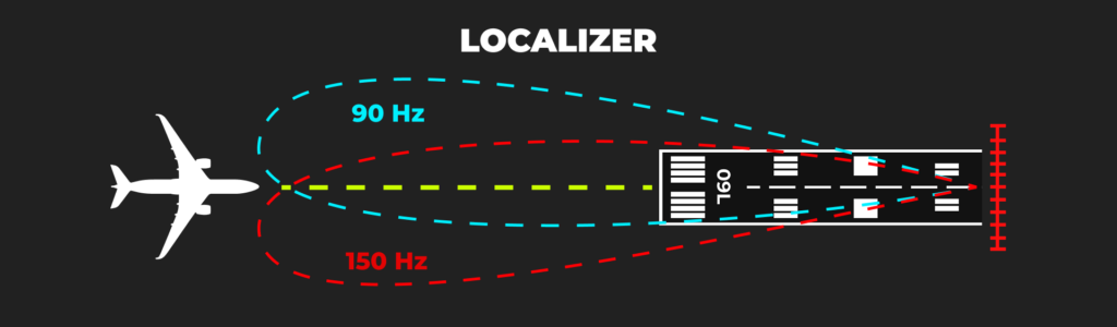
The Localizer
The localizer provides horizontal guidance. It shows the pilot whether the aircraft is left or right of the runway centerline. The antenna is located at the far end of the runway and sends out two overlapping signals. These signals create a course that the aircraft can follow to stay lined up with the runway.
In the cockpit, the localizer appears as a needle on the navigation display. If the aircraft drifts to one side, the needle moves to indicate which way the pilot needs to correct. When the needle is centered, the aircraft is on course.
The signal from the localizer can usually be picked up from up to 25 nautical miles away, although the usable area narrows as you get closer to the runway.
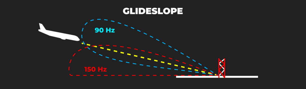
The Glide Slope
While the localizer keeps the aircraft lined up left to right, the glide slope provides vertical guidance. The glide slope antenna is placed beside the runway, usually about 1,000 feet from the threshold. It sends out signals that create a three-degree descent path to the runway.
In the cockpit, another needle shows the aircraft’s vertical position. If the aircraft is above or below the correct path, the needle moves accordingly. The pilot (or autopilot) uses this information to make small adjustments and stay on the correct glide path.
This smooth descent helps ensure that the aircraft touches down at the right point on the runway.
Distance Information
Knowing your position along the approach is just as important as staying on course. Older ILS systems used marker beacons to give this information. These beacons triggered lights and sounds in the cockpit as the aircraft passed certain points on the approach.
Modern systems more often use DME, which stands for Distance Measuring Equipment. DME gives the pilot continuous distance updates, so they always know how far they are from the runway. This is more flexible and reliable than marker beacons, and it has become the standard at most airports.
How Pilots Use ILS
Before starting the approach, pilots prepare by reviewing the airport’s ILS chart. This includes the localizer frequency, the inbound course, and the altitude where they must decide whether to land or go around.
Once the aircraft is within range, the pilot tunes the radio to the correct frequency and confirms it by listening to the Morse code identifier. The localizer signal is picked up first, guiding the aircraft left and right. Then, as the aircraft descends, it intercepts the glide slope and begins a steady approach toward the runway.
Throughout the approach, the pilot monitors both needles to stay on course. If the runway is in sight at the decision height, the pilot lands. If not, they follow a missed approach procedure and try again or divert to another airport.

ILS Categories
ILS systems are divided into categories based on how low the aircraft can go before the pilot needs to see the runway.
- Category I (CAT I): Minimum decision height of 200 feet and visibility of around 550 meters.
- Category II (CAT II): Minimum decision height of 100 feet and visibility of 300 meters.
- Category III (CAT III): Allows landings in very low visibility, sometimes down to zero, if the aircraft and crew are certified.
Not all airports support all categories. Higher categories require more advanced ground equipment and aircraft systems, including autoland capabilities.
Pros and Cons of ILS
Benefits:
- Very accurate and reliable
- Works well in poor weather
- Standardized around the world
Limitations:
- Expensive to install and maintain
- Signals can be affected by terrain or buildings
- Only one approach path per runway
Although satellite-based approaches like RNP and GBAS are becoming more common, ILS is still widely used because of its proven reliability.