Weather fronts are critical features in meteorology that have significant implications for aviation. A front represents the boundary between two distinct air masses with different temperatures, humidity levels, and densities. Understanding weather fronts is essential for pilots to navigate through different weather conditions safely. This chapter explores the types of weather fronts, their characteristics, and their impact on aviation.
Types of Weather Fronts
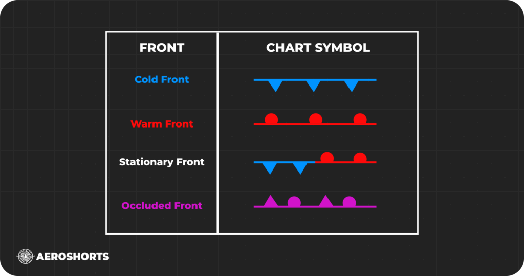
Weather fronts are generally classified into four main types: cold fronts, warm fronts, stationary fronts, and occluded fronts. Each type has unique features and weather patterns associated with it
Cold Front
Characteristics:
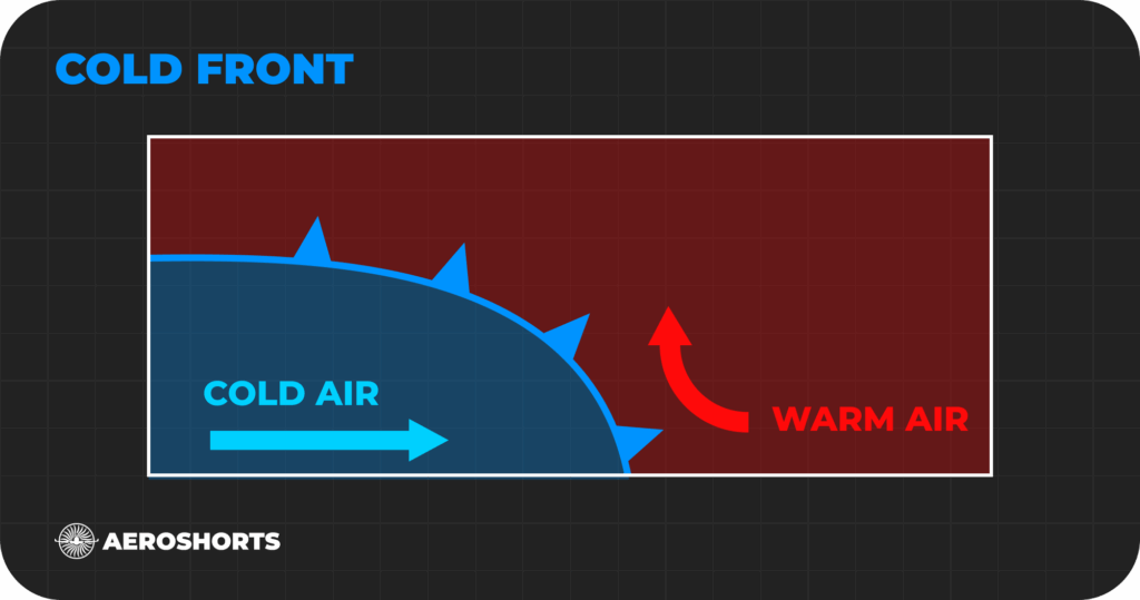
Formation: A cold front forms when a cold air mass pushes into a warmer air mass. Cold fronts move rapidly, often twice as fast as warm fronts.
Weather Patterns: As the cold air, being denser, pushes under the lighter warm air, the warm air is lifted into the troposphere. This process leads to the formation of cumulus or cumulonimbus clouds, often resulting in thunderstorms. As the front passes, expect gusty winds, a sharp temperature drop, and heavy rain, possibly accompanied by hail, thunder, and lightning. Atmospheric pressure also shifts from falling to rising.
Impact on Aviation:
Cold fronts can cause significant turbulence and severe weather, posing challenges for flight operations. Pilots need to be vigilant about wind shear and turbulence ahead of cold fronts and plan for potential diversions or delays due to adverse weather.
Warm Front
Characteristics:
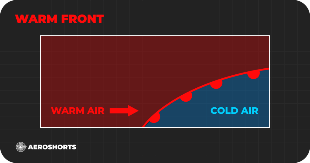
Formation: A warm front forms when a warm air mass moves into a cooler air mass. These fronts typically move more slowly than cold fronts.
Weather Patterns: The warm air rises over the cooler air, leading to cloud formation and steady precipitation. Ahead of a warm front, high clouds like cirrus and cirrostratus appear, followed by middle clouds like altostratus. Rain or snow is common as the front passes, with potential thunderstorms if the air is unstable.
Impact on Aviation:
Warm fronts bring extensive cloud cover and steady precipitation, reducing visibility and potentially causing icing conditions. Pilots should be prepared for instrument flight rules (IFR) conditions and monitor for ice accumulation on aircraft surfaces.
Stationary Front
Characteristics:
Formation: A stationary front occurs when a cold front or warm front stops moving. This happens when two air masses are pushing against each other without one being strong enough to move the other.
Weather Patterns: Stationary fronts can stay in place for days, leading to prolonged cloudiness and precipitation. The weather can vary along the front, with differences in temperature and wind on opposite sides.
Impact on Aviation:
Stationary fronts can cause extended periods of adverse weather, leading to low visibility and potential flight delays. Pilots need to continuously monitor weather conditions and be prepared for potential changes in flight plans.

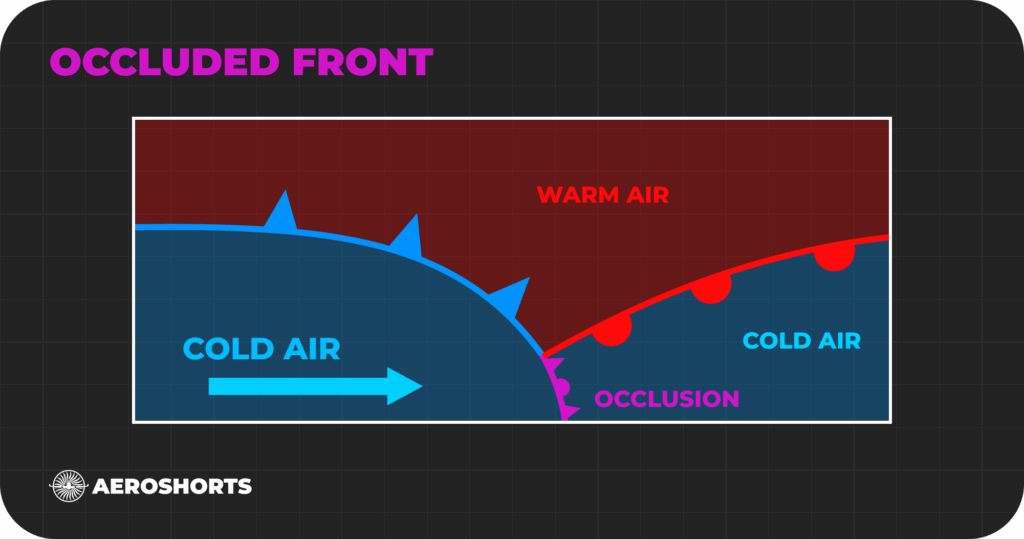
Occluded Front
Characteristics:
Formation: An occluded front forms when a cold front overtakes a warm front. The cold air mass behind the cold front meets the cool air ahead of the warm front, lifting the warm air above.
Weather Patterns: Occluded fronts often bring complex weather, including heavy precipitation and strong winds, typically from cumulonimbus or nimbostratus clouds. Wind direction changes as the front passes, and the temperature may either rise or fall. Clearer skies and drier air often follow the front’s passage.
Impact on Aviation:
Occluded fronts present challenging flying conditions due to the combination of cold and warm front weather patterns. Pilots must be cautious of severe weather and continuously monitor updates to ensure safe navigation.